|
Parish of Castel
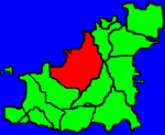
Castel is the largest in area of the 10 parishes in the island of Guernsey. Castel is also, along with the Vale parish, roughly equal second in population after St Peter Port. The parish church of St Marie de Castel is notable for its preserved medieval fresco and for the presence of a pre-Christian neolithic menhir in the churchyard, thought to be carved to represent a female fertility symbol. The church is the closest to a parish boundary and stands on the site of a pagan shrine and probably roman fortifications, hence the name Castel (meaning Castel). Cobo Bay was woodland 10,000 years ago, but there has been evidence of man living there for 4,000 years since Neolithic times. Guernsey 450 flowering plants and many if these can be seen in the parish of Castel. The Castel parish preserves nearly 150 houses more than 200 years old appearing on the Richmond survey published in 1787. Coastal fortifications in Castel include Fort le Crocq, Burton Battery, Fort Houmet, Le Hougue Batteries, Grandes Rocques, Le Guet (the name ‘Le Guet’ stems from the French verb ‘guetter’ meaning watch), Vazon Battery and Loop-hole Tower. The Castel coastline runs from Port Soif to the south end of Vazon. The headlands were heavily fortified during the 2nd World War. It is said that after the war 5,000 tons of soil was used to fill in the trenches and cover up the bunkers at Grandes Rocques. Les Touillets tower existed before the war and had been used as a training tower by the Fire Brigade. During the occupation the Germans modified the tower which was the highest observation point in the Island. In 1975 it was demolished and replaced with the current television tower Features in Castel include:
|


